
NEWS
Thwaites Glacier Doubles Its Sea-Level Rise Forecast
A new ice-sheet model finds tidal pumping under Thwaites Glacier could add 30 millimetres of sea-level rise by 2100, double earlier forecasts.

Thwaites Glacier could add 30 millimetres, plus or minus 6, to global sea level by 2100 even if the climate stays as it is, a Nature Communications model published on 12 October 2026 finds. That total is about twice the 15.2 millimetre average from the ISMIP6 ice-sheet ensemble under the same steady forcing.
The extra water is not a new burst of surface melt. Warm seawater is already flushing kilometres under ice that most forecasts still treat as sitting on the bed.
Warm Water Under Ice That Should Be Grounded
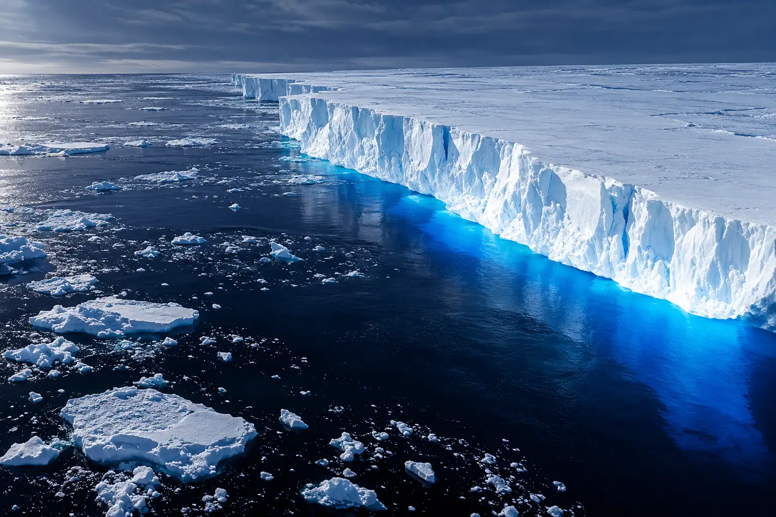
Thwaites sits on the Walgreen Coast of Marie Byrd Land in West Antarctica and spans about 192,000 square kilometres, roughly the size of Senegal or Florida. The Amundsen Sea Embayment around it accounts for about one-third of the mass loss from the whole Antarctic Ice Sheet. Ice there does not fail first on top. It fails where grounded ice lifts and starts to float, the place maps still label as a grounding line.
Mattia Poinelli, who led the work as a UC Irvine postdoctoral scholar in Earth system science and is now a project scientist at UCLA and a NASA Jet Propulsion Laboratory research affiliate, said that picture is too neat. Satellite radar shows a band, sometimes kilometres wide, where tides lift and lower the ice and push pressurised seawater of modified Circumpolar Deep Water origin underneath.
GROUNDING ZONE
- The old map: A grounding line is drawn as a thin, mostly stable mark where ice leaves the bed and begins to float.
- The radar view: A grounding zone is a band 2 to 6 kilometres wide where seawater moves in and out with the tide.
- The motion: That rise and fall, tidal pumping, lets relatively warm water reach ice that models still count as grounded.
Poinelli put the observation in plain terms in the UC Irvine release that accompanied the paper.
Satellite observations demonstrate the existence of a grounding zone, sometimes kilometers wide, where warm ocean water is reaching deep underneath the ice sheets and causing vigorous melting.
Mattia Poinelli, project scientist, UCLA / NASA JPL, UC Irvine announcement
High-resolution images from the Finnish ICEYE radar constellation, taken in 2023, show the main trunk lifting off the bed as far as 10 kilometres inland of the Mouginot Ridge, the bump that still holds the fastest ice. The paper’s authors, who also include Eric Rignot of UC Irvine, Hélène Seroussi of Dartmouth, Joshua Cuzzone, Tyler Pelle of Scripps Institution of Oceanography, and Eric Larour of NASA JPL, built that band into the Ice-sheet and Sea-level System Model, known as ISSM, and asked it to replay the glacier from the mid-1990s to 2023.
25 Kilometres of Retreat the Old Models Could Not Match
Along the Thwaites Main Trunk, the grounding line has moved inland about 25 kilometres since 1996, at about 800 metres a year, down a deep channel. The eastern ice shelf has moved more slowly, 10 to 20 kilometres over the same span, at 400 to 700 metres a year. The ice is still pinned on the Mouginot Ridge, a bathymetric high a few kilometres across that sits about 950 metres below sea level.
Most ice-sheet models still treat that pin as a sharp edge and, in many melt schemes, drive melting toward zero right at the line. Those runs could not match three independent satellite records at once: surface speed, thickness change, and grounding-line position. The UC Irvine team said a version without a zone reconstructed historical change that was four times too mild. Successful hindcasts appeared only when the zone was 2 to 5 kilometres wide. The group ran 105 combinations of zone length and melt rate, then carried the fitted physics forward to 2100 with climate held at recent conditions, a lower-bound case meant to isolate the zone from future ocean warming.
SEA-LEVEL RISE FROM THWAITES BY 2100
| Grounding-zone width | Thwaites addition by 2100 | Mouginot Ridge by 2100 |
|---|---|---|
| ISMIP6 ensemble mean | 15.2 mm, plus or minus 21.8 | Wide spread, some late slowdowns |
| 1 km, plus or minus 1 | 14.3 mm, plus or minus 3.1 | Stays on the ridge |
| 3 km, plus or minus 1 | 19.4 mm, plus or minus 5.2 | About 45 percent unpinning at 2 to 3 km |
| 4 to 6 km (radar-like) | 30 millimetres, plus or minus 6 | About 60 percent unpinning |
A 5 kilometre zone, plus or minus 1, is the length the paper ties to recent ICEYE views of water pushing past the ridge. That is the run that produces 30 millimetres of sea-level rise by 2100, about twice the ISMIP6 mean. The 15.2 millimetre ensemble average also carries a spread of plus or minus 21.8 millimetres, wide enough that some of those older runs even slow down late in the century. Fitting the zone to the observed past both raises the central number and tightens it.
Mouginot Ridge and a 60 Percent Bet
The main trunk is, for now, snagged on that ridge. Poinelli said the hold is temporary. Once the ice unpins, he said, it will keep retreating across a seafloor that slopes downward toward the next high point, the South Ridge. In the runs that use a 4 to 6 kilometre zone, the chance of crossing Mouginot Ridge by 2100 is about 60 percent. In the 5 to 6 kilometre cases, unpinning arrives as early as 2038, and the grounding line can reach South Ridge before 2100. Narrower 2 to 3 kilometre zones cut the chance to about 45 percent. With no zone, or a 1 kilometre band, the ice is still on the ridge at the end of the century.
HOW THE PIN HAS BEEN LOOSENING
- 1940s: Records used by British Antarctic Survey scientists put the start of modern retreat in this decade, with a gradually warming ocean as a major driver after that.
- 1996: The satellite clock on the main trunk begins; about 25 kilometres of grounding-line retreat follows through 2023.
- 2000 onward: Net loss from the glacier exceeds 1000 billion tons of ice, with about 50 billion tons a year more leaving than snowfall replaces.
- 2023: ICEYE radar shows repeated ungrounding up to 10 kilometres inland of Mouginot Ridge.
- 12 October 2026: The ISSM study appears in Nature Communications (volume 17, article 10364), after acceptance on 8 September 2026.
- 2038: Earliest unpinning from Mouginot Ridge in the 5 to 6 kilometre zone runs.
Sixty percent is not a collapse date. It is the chance, in the physics that finally matches the last three decades, that the last useful bump under the main trunk fails before 2100. After that, the next named hold is South Ridge, farther inland on a retrograde bed.
What 30 Millimetres by 2100 Means on the Coast
Thirty millimetres is 1.2 inches. Spread across the world ocean it is a small-sounding figure. Stacked on every other source of rise, and on tides and storms, it is extra water in places that already flood. The paper is explicit that this is Thwaites alone, and that the climate in the forecast is held constant. Any further warming of the Amundsen Sea sits on top of it.
THWAITES IN NUMBERS
- Full collapse: The glacier holds about 65 cm of global sea-level equivalent if it all went, a few centuries’ problem in current assessments, not a 2100 one.
- Today’s share: Ice loss from Thwaites is about 4 percent of global sea-level rise, with about 50 billion tons a year more ice leaving than snowfall puts back.
- Thickness: In places the ice is almost 4000 metres thick.
- Neighbourhood: Thwaites and nearby glaciers more than doubled the ice they sent to the sea from the 1990s to the 2010s; the Amundsen Sea region is about 8 percent of the current 4.5 mm a year of global rise.
Rignot, a UC Irvine professor of Earth system science and co-author, tied the doubled forecast to flood exposure rather than to a nickname.
Most projections up-to-present have struggled to match the rapidity of the mass loss because of missing physics; our new model with more complete physics is able to match the record and then produces projections that are twice larger than before. These results predict greater risk of and exposure for coastal flooding than anticipated in the coming decades.
Eric Rignot, professor of Earth system science, UC Irvine
The same release warned of greater risk of coastal flooding than planners have been using. The 30 millimetres, plus or minus 6, is the Thwaites line in that warning. It is not the West Antarctic Ice Sheet, and it is not a city-by-city flood map. It is the increment that appears once the underside of this one glacier is allowed to melt the way the radar says it already does.
Even a Cooled Ocean Would Not Stop Thwaites
A separate British Antarctic Survey experiment, published in Geophysical Research Letters, asked a harsher question. Rosie Williams and colleagues switched off ocean melting entirely under Thwaites and neighbouring Pine Island Glacier in three ice-sheet models, then ran each for 150 years. Pine Island thickened and began moving back toward the bed it held in the first half of the 20th century. Thwaites did not. It kept losing ice for the whole 150-year span, though the rate slowed as the glacier thinned.
Williams, a glaciologist at the survey and lead author, said the past has already committed the ice.
These results show that past changes in ocean-driven melting have now committed us to unavoidable future ice loss from Thwaites Glacier. This ice loss cannot be undone or prevented by simply cooling the ocean.
Dr Rosie Williams, glaciologist, British Antarctic Survey
The zero-melt case is not a forecast. Seawater under ice always melts some ice. The point of the run is that Thwaites does not grow back even in that impossible cooling. BAS scientists keep losing ice even if oceans cool as the plain reading of the result. Co-author Paul Holland, an ocean modeller at the survey, said historical melting has already committed later generations to extra sea-level rise, and that real ocean warming on top of that history will make the loss worse. The ISSM paper’s constant-climate 30 millimetres sits on the same side of that ledger: the next century’s Thwaites water is not waiting on a new burst of emissions to start.
The Eastern Ice Shelf Has a Decade, Not a Century
The nickname Doomsday Glacier travels farther than the papers. Full collapse of Thwaites would take a few centuries in the assessments used by the International Thwaites Glacier Collaboration, which puts 65 cm if Thwaites collapsed entirely as the sea-level equivalent of the whole glacier. The collaboration also says a general collapse of the West Antarctic Ice Sheet through the 21st and 22nd centuries cannot be ruled out, and that a full Thwaites collapse is unlikely in the next few decades. The new ISSM runs do not overturn that clock. They raise the 2100 bill from this glacier and move the odds on one ridge.
What is already on a short clock is the floating ice in front. The Thwaites Eastern Ice Shelf covers about half of the glacier’s 120 kilometre-wide front. The collaboration’s findings state that this eastern ice shelf is likely to break up and drift away in the coming decade. Recent Sentinel-1 frames have been read by some ice watchers as if that break-up were weeks away. That is not a published result, and a single orbit is not a model. The official finding is already faster than a century and slower than a news-cycle collapse: a decade-scale loss of the last broad shelf in front of Thwaites, while the grounded trunk still hangs on Mouginot Ridge.
WHAT THE NEW RUNS DO AND DO NOT SAY
- Do say: With a radar-like zone, Thwaites adds 30 millimetres, plus or minus 6, by 2100 even with no extra warming, and the wide-zone runs give about a 60 percent chance of leaving Mouginot Ridge this century.
- Do say: Older models that treat a thin grounding line cannot replay the 25 kilometres of main-trunk retreat since 1996 at the same time as the speed and thinning records.
- Do not say: Thwaites collapses in 2100, or that 65 cm arrives this century.
- Do not say: Cutting emissions is pointless. Holland’s BAS team still treats lower greenhouse-gas output as the way to keep extra ocean heat from stacking on ice that is already in motion.
Poinelli’s group also left a hole they named. The zone width is still prescribed, not predicted from the glacier’s changing shape and the water under it. Until that link is in the equations, every millimetre in the table is a fit to the past, carried forward, not a live measurement of next year’s underside.
Flood Maps Built on a Line
The second-order problem is not the nickname. It is the maps. Coastal planning still leans on ice-sheet ensembles that, like ISMIP6, treat the grounded-to-floating change as a line and often damp melt to zero there. Those ensembles’ mean for Thwaites under constant forcing is 15.2 millimetres. The ISSM runs that can actually match 1996 to 2023 sit near 30 millimetres. Rignot’s line about missing physics is the planning point: flood exposure in the coming decades has been counted on a boundary the ice does not use.
Thwaites already sends about 4 percent of global sea-level rise, and about 50 billion tons of ice a year more than it receives. The ISSM forecast holds the climate still and still doubles that glacier’s 2100 line. The BAS 150-year runs show the same ice would keep shrinking if the ocean under it were somehow switched off. Together they describe a glacier whose near-term water is partly already bought, and whose models had been blind to the band of seawater doing the buying.
If the wide-zone odds hold, the next physical event to watch is not a cinematic collapse. It is the day the main trunk comes off Mouginot Ridge, which the 5 to 6 kilometre runs allow as early as 2038, and then the long slide toward South Ridge on a bed that deepens inland.

Ohtani Game 4 Logoman Card Sells for $3.24 Million

Cole Kmet’s Season Ends, and Chicago’s Tight End Plan Starts

NBA Seeks Soccer Money After EuroLeague Clubs Refused

Amazon’s First Bond Tests Leave the Broccoli Chair Empty

Tyrese Maxey Owns the Night Built for LeBron James

Warsh Rejects Rate Guidance and Still Moves Markets

Dana-Farber Exits an MGB Medicare Advantage Network Early

NASA Launches the Roman Space Telescope’s Cosmic Bet

OpenAI’s Cyber Letter Puts the Defense Bill on Governments

Russia Recycles Its Old Warning Over Storm Shadow Plants
-
 BUSINESS2 months ago
Warsh Rejects Rate Guidance and Still Moves Markets
-
 BUSINESS1 month ago
Dana-Farber Exits an MGB Medicare Advantage Network Early
-
 NEWS2 months ago
NASA Launches the Roman Space Telescope’s Cosmic Bet
-
 NEWS2 months ago
OpenAI’s Cyber Letter Puts the Defense Bill on Governments
-
 NEWS2 months ago
Russia Recycles Its Old Warning Over Storm Shadow Plants
-

 ENTERTAINMENT4 weeks ago
Primetime’s $2.7 Million Preview Tops Pitt’s Costlier Film
-

 BUSINESS2 months ago
Jet Drones Lock Down Kyiv and Strip Kherson of Heat
-

 ENTERTAINMENT2 months ago
Midnight Spider-Man Turns Peter Parker Into Oscorp’s Hybrid